Friday, 8 April 2016

one year later... plans afoot

Well seems time flies when we are busy, after the last post of March 2015 things slowed down.
Our busy season finished a little after April, and plans were hatched to have a holiday, one month, August 2015.
 Leaving Karamea our quiet haven, we enter the realm of Nelson and Golden Bay to explore.

 Spent time in Takaka and thought of walking some of the Heaphy Track, this was not to be as snow fall hindered our start.
 An alternative plan was hatched. Abel Tasman Track was a better option for a few days of tramping.

 Day one from Marahau the start of the trail was a rainy day and got heavier as we soldiered on toward Anchorage Hut for our first night.
 Roughly 3 hours slow climb from tidal flats of reeds across a boardwalk, many improvements made since the last time I walked this track. Mostly regenerating forest scrub and well defined track is easy to follow.
Anchorage Hut is recently been rebuilt, with 4 spacious bunk rooms with toilet facilities close and undercover. Large common room and kitchen area, must bring own cooking stove and gas as well as pots.

 Day two, has a tidal crossing if you time this well save an hour or so depending on walking speed. if not, a climb back up the ridge you descended the previous day, good views of Torrent Bay and along the coast back to Marahau.
 Follow the sign posts carefully as there are a few side trips to the beaches along the way. When you approach Torrent Bay you will see the large orange triangles on poles crossing the estuary, the tidal crossing mentioned earlier.
 Today we are heading for Bark Bay about 5 hours walking with breaks to enjoy the landscape and coastal views, much of the time walking in the forest with glimpses of the coastline and reclusive hideaways.
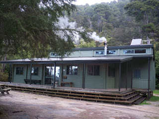
 Back Bay Hut is set back from the sea, with a rustic style hut with potbelly stove and a good supply of wood out the back in a shed with an axe, take care when chopping, there is a ranger station close but not always manned.

                                  View of Bark Bay as we climb the headland toward Tonga Bay.


 Day three, an early start as this is the longest day and the most ground to cover as we head to Awaroa Hut. Follow the track and read the signs carefully, a bit of track maintenance is expected as this is a popular walking track for day walkers and trampers.
 Many encounters with bird life including a Morepork in the middle of the day, unusual.


 Continue until you reach Awaroa Lodge sign indicated to take the right hand track down, but we opted to trek on to the Awaroa Inlet and prepare for the tidal walk to our destination, Awaroa Hut.
 A coastal style hut, outlook of the tidal crossing of the Awaroa Inlet toward Totaranui. We are not doing this crossing for this trip.

 Day four, an early start to reach the pick up point for our boat trip from the beach at you guess, Awaroa Beach, surprise it is deserted but beautiful, especially at sunrise.


 This was a great trail to share and the new improvements make the journey a little easier and memorable. The weather in August for us was wet to start, every day that followed improved so when we water taxied back the sea was perfectly calm.
Tuesday, 24 March 2015

Fenian Track mid-morning excursion


 A gentle stroll on the Fenian track to Maloneys Bluff was met with some new windfall, just enough to start our adventure.
 Later we encountered the destruction area of trees from the extreme wind in April 2014, since been cleared off the track the remnants are stacked high, these will be devoured by fungus and turned to hummus to feed the forest.

Passing the side trail to the caves we continued over Cavern Creek bridge and Fenian Stream bridges, take next right side trail to Fenian workings.

 35 minutes along well marked trail to no evidence of any workings, too many trees down.

 Saw a lot of mushrooms and toadstools.

Return time for the day 4 hours approx.

Friday, 20 February 2015

Revisit Zig Zag Track

A mid morning excursion with our new friend, we three set out to explore the eastern side of the South Terrace of Karamea.

 We travel across the Karamea River bridge and turn left on Arapito Road, drive 1 kilometre to a car park and start the ascent to the beginning of the track.

 A gentle and graded walk up the face of the terrace toward the summit, zig zagging up a well defined trail passing recent windfall and views of the valley below.

 Since the climate has been so dry, no fungi are present. We continue up and around the many switch backs till we reach the top and find a junction. One way leads to the road on top of the terrace and the other to a lookout, this is our destination today.


This was a pleasant day to share.
Approximately 1 hour walk depending on fitness, and 1 hour return a good stroll to raise the heart beat and get a small work out, look forward to the next walk in the Kahurangi National Park, West Coast, South Island, New Zealand.


Tuesday, 10 February 2015

Visit the Big Rimu Tree ... Karamea

                            Day out in the nature to visit an old local of the forest, Big Rimu Tree.

 Giant example of a guardian in the Kahurangi National Park, surrounded by lush vegetation as far as the eye can see, 20 minutes easy walk along a well marked trail climbing at times over gentle rises to finally descend to end the trail and meet the tree.

 Birds are not to many, saw a few Fantails above our heads as they swooped down to catch insects on the wing.


A great day to spend time in the bush with friends.

Flora study experiment of Koru

Thanks to all for sharing the day excursion and work done by Department of Conservation for maintaining the tracks.

This trail is 9 km from the village of Karamea on the Umere Road, following the Karamea River.

Friday, 30 January 2015

2015 long dry

Hard to believe Karamea has had no substantial rain for a month, long dry days, temperatures ranging 26 degrees C to 32.5 degrees C.

 We are so looking for rain to fall despite the long weekend for the travelers in town, drinking water is more important at this stage of the year.

 I am sure we will receive some soon, the sandflies are at an all time high signaling the onset of precipitation.

 When ever I drive to the start of the Heaphy Track the roads are lined with brown grass and low waters in creeks that are normally flowing well, stock are frequenting troughs more regular and bird life is less, quiet sunset chorus... not much to say I would think.

 Anyway life goes on.

 Tramping on the Heaphy has slowed down a lot, as school has returned and festivals have started, a slower time for businesses in Karamea is expected, it will get busier after mid February as past years have shown, heres hoping.

 I have several small day walks planned for the future and one major trek in winter, this will be my time off annual leave, a chance to unwind and plan the next stage of my working year.

 So for a final note to January, good suntan and busy transport season so far and may it continue.

Sunday, 23 November 2014

weather dependent

When planning any excursion in the nature, outdoors is to be respected as is the weather.

Long range forecasts are handy, knowing your environment and studying topography maps gives an idea of terrain especially of flood prone sections of track.
Watching weather patterns and listening to local radio station updates can make a difference to getting it semi right. As we all know weather can change quickly and result in difficult decisions, my advice is if you are in a hut and there is no threat to life, stay where you are and wait it out, New Zealand rivers come up and go down just as fast.

 Example. In Karamea these past 24 hours a change of high water to flood proportions to now receding waters and low lying debris, has taught us to be observant and follow our instincts to prepare for a long wait.

Surrounded by water, depth unknown, a lone Pukeko finds high ground beside a Cabbage tree(Australis Cordyline) and is joined by a colleague for comfort, both regain strength as water rises.

There is still water lying around low points in the area, access is restored, some roads are open, rivers are dropping.

Be aware 
Prepare
Spare gear

When packing clothes for outdoor walking trips, use a pack liner and separate dry bags to keep belongings, food and sleeping bags moisture free. A happy adventure is well planned and results in good times and great stories, if possible walk with a friend or group, safety in numbers.

Thursday, 20 November 2014

daily walks to increase endurance

When any walking is planned and enabled, it requires endurance, strength, and readiness.

 Today I walk to Karamea River and Estuary with the family, a gentle amble is the pace of the day, with photo ops a must.
 A wander first on paved path to where it crosses a sealed road, an unsealed road is the main route until we meet the estuary beach, sand and river rocks, many stunning pieces of driftwood washed, over decades, revealing works of art.

 Oyster Catches and Seagulls wait for the first push of the tide, fresh feed for the masses, another rich ecosystem of shellfish, crabs, small fish, eels, to balance the fish stocks of the area.

 Karamea Estuary was a major shipping port for the West Coast, trading in timber, flax and gold.
 1929 Murchison Earthquake changed the course of the river and silted the Harbour.
There are remaining wharf poles to show the setup of the port, a replica carriage on rails and information boards explains the operations of this enhanced walkway experience.

 The path resumes following the orange markers, laid out by KEEP ( Karamea Estuary Enhancement Project ), to a seat overlooking the water and sand dunes bordering the Tasman Sea.

 A boardwalk bridge navigates the wetlands to a crushed lime path back to Wharf Road.